Main Content


Agency Copyright Notice

Agency Copyright Notice

Agency Copyright Notice

Agency Copyright Notice

Agency Copyright Notice

Agency Copyright Notice

Agency Copyright Notice
-
Introduction :: Indian Ocean
-
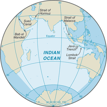
 The Indian Ocean is the third largest of the world's five oceans (after the Pacific Ocean and Atlantic Ocean, but larger than the Southern Ocean and Arctic Ocean). Four critically important access waterways are the Suez Canal (Egypt), Bab el Mandeb (Djibouti-Yemen), Strait of Hormuz (Iran-Oman), and Strait of Malacca (Indonesia-Malaysia).The decision by the International Hydrographic Organization in the spring of 2000 to delimit a fifth ocean, the Southern Ocean, removed the portion of the Indian Ocean south of 60 degrees south latitude.
 -
Geography :: Indian Ocean
-
body of water between Africa, the Southern Ocean, Asia, and Australia
20 00 S, 80 00 E
Political Map of the World
total: 68.556 million sq km
note: includes Andaman Sea, Arabian Sea, Bay of Bengal, Flores Sea, Great Australian Bight, Gulf of Aden, Gulf of Oman, Java Sea, Mozambique Channel, Persian Gulf, Red Sea, Savu Sea, Strait of Malacca, Timor Sea, and other tributary water bodies
almost 7 times the size of the US
66,526 km
northeast monsoon (December to April), southwest monsoon (June to October); tropical cyclones occur during May/June and October/November in the northern Indian Ocean and January/February in the southern Indian Ocean
surface dominated by a major gyre (broad, circular system of currents) in the southern Indian Ocean and a unique reversal of surface currents in the northern Indian Ocean; ocean floor is dominated by the Mid-Indian Ocean Ridge and subdivided by the Southeast Indian Ocean Ridge, Southwest Indian Ocean Ridge, and Ninetyeast Ridge
major surface currents: the counterclockwise Indian Ocean Gyre comprised of the warm Agulhas and East Madagascar Currents in the west, the South Indian Current in the south, the cold West Australian Current in the east, and the South Equatorial Current in the north; a distinctive annual reversal of surface currents occurs in the northern Indian Ocean; low atmospheric pressure over southwest Asia from hot, rising, summer air results in the southwest monsoon and southwest-to-northeast winds and clockwise currents, while high pressure over northern Asia from cold, falling, winter air results in the northeast monsoon and northeast-to-southwest winds and counterclockwise currents
elevation extremes: -7,258 m lowest point: Java Trenchmean depth: -3,741 m0 highest point: sea level
oil and gas fields, fish, shrimp, sand and gravel aggregates, placer deposits, polymetallic nodules
occasional icebergs pose navigational hazard in southern reaches
marine pollution caused by ocean dumping, waste disposal, and oil spills; deep sea mining; oil pollution in Arabian Sea, Persian Gulf, and Red Sea; coral reefs threatened due climate change, direct human pressures, and inadequate governance, awareness, and political will; loss of biodiversity; endangered marine species include the dugong, seals, turtles, and whales
major chokepoints include Bab el Mandeb, Strait of Hormuz, Strait of Malacca, southern access to the Suez Canal, and the Lombok Strait -
Government :: Indian Ocean
-
etymology: named for the country of India, which makes up much of its northern border
-
Economy :: Indian Ocean
-
The Indian Ocean provides major sea routes connecting the Middle East, Africa, and East Asia with Europe and the Americas. It carries a particularly heavy traffic of petroleum and petroleum products from the oilfields of the Persian Gulf and Indonesia. Its fish are of great and growing importance to the bordering countries for domestic consumption and export. Fishing fleets from Russia, Japan, South Korea, and Taiwan also exploit the Indian Ocean, mainly for shrimp and tuna. Large reserves of hydrocarbons are being tapped in the offshore areas of Saudi Arabia, Iran, India, and western Australia. An estimated 40% of the world's offshore oil production comes from the Indian Ocean. Beach sands rich in heavy minerals and offshore placer deposits are actively exploited by bordering countries, particularly India, South Africa, Indonesia, Sri Lanka, and Thailand.
-
Transportation :: Indian Ocean
-
major seaport(s): Chennai (Madras, India); Colombo (Sri Lanka); Durban (South Africa); Jakarta (Indonesia); Kolkata (Calcutta, India); Melbourne (Australia); Mumbai (Bombay, India); Richards Bay (South Africa)
-
Military and Security :: Indian Ocean
-
the International Maritime Bureau continues to report the territorial waters of littoral states and offshore waters as high risk for piracy and armed robbery against ships, particularly in the Gulf of Aden, along the east coast of Africa, the Bay of Bengal, and the Strait of Malacca; the presence of several naval task forces in the Gulf of Aden and additional anti-piracy measures on the part of ship operators, including the use of on-board armed security teams, have reduced incidents of piracy; in response, Somali-based pirates, using hijacked fishing trawlers as "mother ships" to extend their range, shifted operations as far south as the Mozambique Channel, eastward to the vicinity of the Maldives, and northeastward to the Strait of Hormuz; 2017 saw an increase in attacks over 2016, with three incidents in the Gulf of Aden, one in the Red Sea, and five off the coast of Somalia;Operation Ocean Shield, the NATO naval task force established in 2009 to combat Somali piracy, concluded its operations in December 2016 as a result of the drop in reported incidents over the last few years; the EU naval mission, Operation ATALANTA, continues its operations in the Gulf of Aden and Indian Ocean through 2020; naval units from Japan, India, and China also operate in conjuction with EU forces; China has established a logistical base in Djibouti to support its deployed naval units in the Horn of Africa
-
Transnational Issues :: Indian Ocean
-
some maritime disputes (see littoral states)