

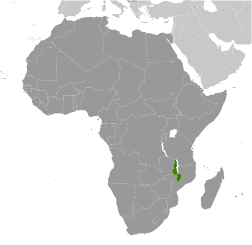
Africa :: MALAWI
Introduction :: MALAWI
-
Established in 1891, the British protectorate of Nyasaland became the independent nation of Malawi in 1964. After three decades of one-party rule under President Hastings Kamuzu BANDA, the country held multiparty presidential and parliamentary elections in 1994, under a provisional constitution that came into full effect the following year. President Bingu wa MUTHARIKA, elected in 2004 after a failed attempt by the previous president to amend the constitution to permit another term, struggled to assert his authority against his predecessor and subsequently started his own party, the Democratic Progressive Party in 2005. MUTHARIKA was reelected to a second term in 2009. He oversaw some economic improvement in his first term, but was accused of economic mismanagement and poor governance in his second term. He died abruptly in 2012 and was succeeded by vice president, Joyce BANDA, who had earlier started her own party, the People's Party. MUTHARIKA's brother, Peter MUTHARIKA, defeated BANDA in the 2014 election. Population growth, increasing pressure on agricultural lands, corruption, and the scourge of HIV/AIDS pose major problems for Malawi.
Geography :: MALAWI
-
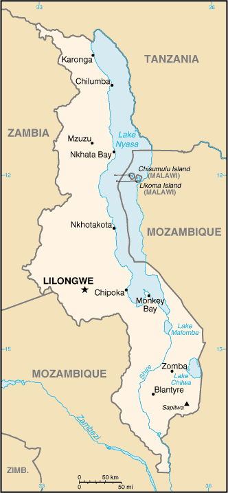
Southern Africa, east of Zambia, west and north of Mozambique13 30 S, 34 00 EAfricatotal: 118,484 sq kmland: 94,080 sq kmwater: 24,404 sq kmcountry comparison to the world: 100slightly smaller than Pennsylvaniatotal: 2,857 kmborder countries (3): Mozambique 1,498 km, Tanzania 512 km, Zambia 847 km0 km (landlocked)none (landlocked)sub-tropical; rainy season (November to May); dry season (May to November)narrow elongated plateau with rolling plains, rounded hills, some mountainsmean elevation: 779 melevation extremes: lowest point: junction of the Shire River and international boundary with Mozambique 37 mhighest point: Sapitwa (Mount Mlanje) 3,002 mlimestone, arable land, hydropower, unexploited deposits of uranium, coal, and bauxiteagricultural land: 59.2%arable land 38.2%; permanent crops 1.4%; permanent pasture 19.6%forest: 34%other: 6.8% (2011 est.)740 sq km (2012)NAdeforestation; land degradation; water pollution from agricultural runoff, sewage, industrial wastes; siltation of spawning grounds endangers fish populationsparty to: Biodiversity, Climate Change, Climate Change-Kyoto Protocol, Desertification, Endangered Species, Environmental Modification, Hazardous Wastes, Marine Life Conservation, Ozone Layer Protection, Ship Pollution, Wetlandssigned, but not ratified: Law of the Sealandlocked; Lake Nyasa, some 580 km long, is the country's most prominent physical feature; it contains more fish species than any other lake on earth
People and Society :: MALAWI
-
18,570,321note: estimates for this country explicitly take into account the effects of excess mortality due to AIDS; this can result in lower life expectancy, higher infant mortality, higher death rates, lower population growth rates, and changes in the distribution of population by age and sex than would otherwise be expected (July 2016 est.)country comparison to the world: 62noun: Malawian(s)adjective: MalawianChewa 32.6%, Lomwe 17.6%, Yao 13.5%, Ngoni 11.5%, Tumbuka 8.8%, Nyanja 5.8%, Sena 3.6%, Tonga 2.1%, Ngonde 1%, other 3.5%English (official), Chichewa (common), Chinyanja, Chiyao, Chitumbuka, Chilomwe, Chinkhonde, Chingoni, Chisena, Chitonga, Chinyakyusa, ChilambyaChristian 82.6%, Muslim 13%, other 1.9%, none 2.5% (2008 est.)Malawi has made great improvements in maternal and child health, but has made less progress in reducing its high fertility rate. In both rural and urban areas, very high proportions of mothers are receiving prenatal care and skilled birth assistance, and most children are being vaccinated. Malawi’s fertility rate, however, has only declined slowly, decreasing from more than 7 children per woman in the 1980s to about 5.5 today. Nonetheless, Malawians prefer smaller families than in the past, and women are increasingly using contraceptives to prevent or space pregnancies. Rapid population growth and high population density is putting pressure on Malawi’s land, water, and forest resources. Reduced plot sizes and increasing vulnerability to climate change, further threaten the sustainability of Malawi’s agriculturally based economy and will worsen food shortages. About 80% of the population is employed in agriculture.Historically, Malawians migrated abroad in search of work, primarily to South Africa and present-day Zimbabwe, but international migration became uncommon after the 1970s, and most migration in recent years has been internal. During the colonial period, Malawians regularly migrated to southern Africa as contract farm laborers, miners, and domestic servants. In the decade and a half after independence in 1964, the Malawian Government sought to transform its economy from one dependent on small-scale farms to one based on estate agriculture. The resulting demand for wage labor induced more than 300,000 Malawians to return home between the mid-1960s and the mid-1970s. In recent times, internal migration has generally been local, motivated more by marriage than economic reasons.0-14 years: 46.53% (male 4,299,076/female 4,341,129)15-24 years: 20.49% (male 1,889,240/female 1,915,843)25-54 years: 27.26% (male 2,512,247/female 2,549,766)55-64 years: 3.03% (male 268,691/female 294,713)65 years and over: 2.69% (male 220,608/female 279,008) (2016 est.)total dependency ratio: 94.5%youth dependency ratio: 87.9%elderly dependency ratio: 6.7%potential support ratio: 14.9% (2015 est.)total: 16.5 yearsmale: 16.3 yearsfemale: 16.6 years (2016 est.)country comparison to the world: 2263.32% (2016 est.)country comparison to the world: 241.3 births/1,000 population (2016 est.)country comparison to the world: 78.1 deaths/1,000 population (2016 est.)country comparison to the world: 940 migrant(s)/1,000 population (2016 est.)country comparison to the world: 91urban population: 16.3% of total population (2015)rate of urbanization: 3.77% annual rate of change (2010-15 est.)LILONGWE (capital) 905,000; Blantyre-Limbe 808,000 (2015)at birth: 1.02 male(s)/female0-14 years: 0.99 male(s)/female15-24 years: 0.99 male(s)/female25-54 years: 0.99 male(s)/female55-64 years: 0.91 male(s)/female65 years and over: 0.79 male(s)/femaletotal population: 0.98 male(s)/female (2016 est.)18.9note: median age at first birth among women 25-29 (2010 est.)634 deaths/100,000 live births (2015 est.)country comparison to the world: 24total: 44.8 deaths/1,000 live birthsmale: 51.5 deaths/1,000 live birthsfemale: 38 deaths/1,000 live births (2016 est.)country comparison to the world: 44total population: 61.2 yearsmale: 59.2 yearsfemale: 63.2 years (2016 est.)country comparison to the world: 1975.54 children born/woman (2016 est.)country comparison to the world: 846.1% (2010)11.4% of GDP (2014)country comparison to the world: 350.02 physicians/1,000 population (2009)1.3 beds/1,000 population (2011)improved:urban: 95.7% of populationrural: 89.1% of populationtotal: 90.2% of populationunimproved:urban: 4.3% of populationrural: 10.9% of populationtotal: 9.8% of population (2015 est.)improved:urban: 47.3% of populationrural: 39.8% of populationtotal: 41% of populationunimproved:urban: 52.7% of populationrural: 60.2% of populationtotal: 59% of population (2015 est.)9.11% (2015 est.)country comparison to the world: 9976,300 (2015 est.)country comparison to the world: 1026,700 (2015 est.)country comparison to the world: 11degree of risk: very highfood or waterborne diseases: bacterial and protozoal diarrhea, hepatitis A, and typhoid fevervectorborne diseases: malaria and dengue feverwater contact disease: schistosomiasisanimal contact disease: rabies (2016)4.3% (2014)country comparison to the world: 16816.7% (2014)country comparison to the world: 526.9% of GDP (2014)country comparison to the world: 60definition: age 15 and over can read and writetotal population: 65.8%male: 73%female: 58.6% (2015 est.)total: 11 yearsmale: 11 yearsfemale: 11 years (2011)total number: 993,318percentage: 26% (2006 est.)total: 8.6%male: 9.1%female: 8.2% (2013 est.)
Government :: MALAWI
-
conventional long form: Republic of Malawiconventional short form: Malawilocal long form: Dziko la Malawilocal short form: Malawiformer: British Central African Protectorate, Nyasaland Protectorate, Nyasalandetymology: named for the East African Maravi kingdom of the 16th century; the word "maravi" means "fire flames"presidential republicname: Lilongwegeographic coordinates: 13 58 S, 33 47 Etime difference: UTC+2 (7 hours ahead of Washington, DC, during Standard Time)28 districts; Balaka, Blantyre, Chikwawa, Chiradzulu, Chitipa, Dedza, Dowa, Karonga, Kasungu, Likoma, Lilongwe, Machinga, Mangochi, Mchinji, Mulanje, Mwanza, Mzimba, Neno, Ntcheu, Nkhata Bay, Nkhotakota, Nsanje, Ntchisi, Phalombe, Rumphi, Salima, Thyolo, Zomba6 July 1964 (from the UK)Independence Day (Republic Day), 6 July (1964)previous 1953 (preindependence), 1966; latest drafted January to May 1994, approved 16 May 1994, entered into force 18 May 1995; amended several times, last in 2013 (2016)mixed legal system of English common law and customary law; judicial review of legislative acts in the Supreme Court of Appealaccepts compulsory ICJ jurisdiction with reservations; accepts ICCt jurisdictioncitizenship by birth: nocitizenship by descent only: at least one parent must be a citizen of Malawidual citizenship recognized: noresidency requirement for naturalization: 7 years18 years of age; universalchief of state: President Arthur Peter MUTHARIKA (since 31 May 2014); Vice President Saulos CHILIMA (since 31 May 2014); note - the president is both chief of state and head of governmenthead of government: President Arthur Peter MUTHARIKA (since 31 May 2014); Vice President Saulos CHILIMA (since 31 May 2014)cabinet: Cabinet named by the presidentelections/appointments: president directly elected by simple majority popular vote for a 5-year term (eligible for a second term); election last held on 20 May 2014 (next to be held in May 2019)election results: Peter MUTHARIKA elected president; percent of vote - Peter MUTHARIKA (DPP) 36.4%, Lazarus CHAKWERA (MCP) 27.8%, Joyce BANDA (PP) 20.2%, Atupele MULUZI (UDF) 13.7%, other 1.9%description: unicameral National Assembly (193 seats; members directly elected in single-seat constituencies by simple majority vote to serve 5-year terms)elections: last held on 20-22 May 2014 (next to be held in May 2019)election results: percent of vote by party - DPP 22.0%, MCP 17.4%, PP 18.5%, UDF 9.6%, other 2.8%, independent 29.7%; seats by party - DPP 51, MCP 48, PP 26, UDF 14, other 2, independent 52highest court(s): Supreme Court of Appeal (consists of the chief justice and at least 3 judges)judge selection and term of office: Supreme Court chief justice appointed by the president and confirmed by the National Assembly; other judges appointed by the president upon recommendation of the Judicial Service Commission, which regulates judicial officers; judges serve until age 65subordinate courts: High Court; magistrate courts; Industrial Relations Court; district and city traditional or local courtsAlliance for Democracy or AFORD [Godfrey SHAWA]Democratic Progressive Party or DPP [Peter MUTHARIKA]Malawi Congress Party or MCP [Lazarus CHAKWERA]People's Party or PP [Joyce BANDA]United Democratic Front or UDF [Atupele MULUZI]Council for NGOs in Malawi or CONGOMA (human rights, democracy, and development)Human Rights Consultative Committee or HRCC (human rights)Malawi Economic Justice Network or MEJN (pro economic growth, development, government accountability)Malawi Law Society (an umbrella organization of all lawyers in Malawi)Public Affairs Committee or PAC (promotes democracy, development, peace and unity)ACP, AfDB, AU, C, CD, COMESA, FAO, G-77, IAEA, IBRD, ICAO, ICCt, ICRM, IDA, IFAD, IFC, IFRCS, ILO, IMF, IMO, Interpol, IOC, IOM, IPU, ISO (correspondent), ITSO, ITU, ITUC (NGOs), MIGA, MINURSO, MONUSCO, NAM, OPCW, SADC, UN, UNCTAD, UNESCO, UNIDO, UNISFA, UNOCI, UNWTO, UPU, WCO, WFTU (NGOs), WHO, WIPO, WMO, WTOchief of mission: Ambassador Edward Yakobe SAWERENGERA (since 16 September 2016)chancery: 2408 Massachusetts Avenue NW, Washington, DC 20008telephone: [1] (202) 721-0270FAX: [1] (202) 721-0288chief of mission: Ambassador Virginia E. PALMER (since 5 February 2015)embassy: 16 Jomo Kenyatta Road, Lilongwe 3mailing address: P.O. Box 30016, Lilongwe 3, Malawitelephone: [265] (1) 773-166FAX: [265] (1) 770-471three equal horizontal bands of black (top), red, and green with a radiant, rising, red sun centered on the black band; black represents the native peoples, red the blood shed in their struggle for freedom, and green the color of nature; the rising sun represents the hope of freedom for the continent of Africalion; national colors: black, red, greenname: "Mulungu dalitsa Malawi" (Oh God Bless Our Land of Malawi)lyrics/music: Michael-Fredrick Paul SAUKAnote: adopted 1964
Economy :: MALAWI
-
Landlocked Malawi ranks among the world's most densely populated and least developed countries. The country’s economic performance has historically been constrained by policy inconsistency, macroeconomic instability, limited connectivity to the region and the world, and poor health and education outcomes that limit labor productivity. The economy is predominately agricultural with about 80% of the population living in rural areas. Agriculture accounts for about one-third of GDP and 90% of export revenues. The performance of the tobacco sector is key to short-term growth as tobacco accounts for more than half of exports.The economy depends on substantial inflows of economic assistance from the IMF, the World Bank, and individual donor nations. In 2006, Malawi was approved for relief under the Heavily Indebted Poor Countries program. Between 2005 and 2009 Malawi’s government exhibited improved financial discipline under the guidance of Finance Minister Goodall GONDWE and signed a three-year IMF Poverty Reduction and Growth Facility worth $56 million. The government announced infrastructure projects that could yield improvements, such as a new oil pipeline for better fuel access, and the potential for a waterway link through Mozambican rivers to the ocean for better transportation options.Since 2009, however, Malawi has experienced some setbacks, including a general shortage of foreign exchange, which has damaged its ability to pay for imports, and fuel shortages that hinder transportation and productivity. In October 2013, the African Development Bank, the IMF, several European countries, and the US indefinitely froze $150 million in direct budgetary support in response to a high level corruption scandal, called “Cashgate,” citing a lack of trust in the government’s financial management system and civil service. Most of the frozen donor funds — which accounted for 40% of the budget — have been channeled through non-governmental organizations in the country. The government has failed to address barriers to investment such as unreliable power, water shortages, poor telecommunications infrastructure, and the high costs of services. Investment had fallen continuously for several years, but rose 4 percentage points in 2014 to 17% of GDP.The government faces many challenges, including developing a market economy, improving educational facilities, addressing environmental problems, dealing with HIV/AIDS, and satisfying foreign donors on anti-corruption efforts.$20.36 billion (2015 est.)$19.78 billion (2014 est.)$18.71 billion (2013 est.)note: data are in 2015 US dollarscountry comparison to the world: 145$6.416 billion (2015 est.)3% (2015 est.)5.7% (2014 est.)5.2% (2013 est.)country comparison to the world: 102$1,100 (2015 est.)$1,100 (2014 est.)$1,100 (2013 est.)note: data are in 2015 US dollarscountry comparison to the world: 223-12.7% of GDP (2015 est.)-9.9% of GDP (2014 est.)-16.6% of GDP (2013 est.)country comparison to the world: 169household consumption: 75.6%government consumption: 17.3%investment in fixed capital: 12%investment in inventories: 2.8%exports of goods and services: 43.5%imports of goods and services: -51.2% (2015 est.)agriculture: 32.7%industry: 17.2%services: 50.1% (2015 est.)tobacco, sugarcane, cotton, tea, corn, potatoes, cassava (manioc, tapioca), sorghum, pulses, groundnuts, Macadamia nuts; cattle, goatstobacco, tea, sugar, sawmill products, cement, consumer goods4.1% (2015 est.)country comparison to the world: 505.747 million (2007 est.)country comparison to the world: 71agriculture: 90%industry and services: 10% (2003 est.)NA%52.4% (2004 est.)lowest 10%: 3%highest 10%: 31.9% (2004)39 (2004)country comparison to the world: 69revenues: $1.26 billionexpenditures: $1.51 billion (2015 est.)19.6% of GDP (2015 est.)country comparison to the world: 163-3.9% of GDP (2015 est.)country comparison to the world: 14154.2% of GDP (2015 est.)58.5% of GDP (2014 est.)country comparison to the world: 721 July - 30 June21.2% (2015 est.)24.4% (2014 est.)country comparison to the world: 22015% (31 December 2009)15% (31 December 2008)country comparison to the world: 1244.9% (31 December 2015 est.)44.29% (31 December 2014 est.)country comparison to the world: 2$512.3 million (31 December 2015 est.)$567.9 million (31 December 2014 est.)country comparison to the world: 163$1.481 billion (31 December 2014 est.)$1.2 billion (31 December 2013 est.)country comparison to the world: 164$724.5 million (31 December 2015 est.)$826.6 million (31 December 2014 est.)country comparison to the world: 168$753.6 million (31 December 2012 est.)$1.384 billion (31 December 2011 est.)$1.363 billion (31 December 2010 est.)country comparison to the world: 108-$568 million (2015 est.)-$494 million (2014 est.)country comparison to the world: 101$1.278 billion (2015 est.)$1.528 billion (2014 est.)country comparison to the world: 150tobacco 53%, tea, sugar, cotton, coffee, peanuts, wood products, apparel (2010 est.)Belgium 15.8%, Zimbabwe 12%, India 6.9%, South Africa 6.2%, US 6%, Russia 5.6%, Germany 4.6% (2015)$2.607 billion (2015 est.)$2.744 billion (2014 est.)country comparison to the world: 152food, petroleum products, semi-manufactures, consumer goods, transportation equipmentSouth Africa 26.4%, China 16.7%, India 12%, Zambia 10.3%, Tanzania 6% (2015)$693.1 million (31 December 2015 est.)$625.2 million (31 December 2014 est.)country comparison to the world: 139$1.715 billion (31 December 2015 est.)$1.637 billion (31 December 2014 est.)country comparison to the world: 153$NA$NAMalawian kwachas (MWK) per US dollar -499.6 (2015 est.)424.9 (2014 est.)424.9 (2013 est.)249.11 (2012 est.)156.93 (2011 est.)
Energy :: MALAWI
-
population without electricity: 14,900,000electrification - total population: 9%electrification - urban areas: 32%electrification - rural areas: 4% (2013)2.1 billion kWh (2014 est.)country comparison to the world: 1351.9 billion kWh (2014 est.)country comparison to the world: 1420 kWh (2013 est.)country comparison to the world: 1670 kWh (2013 est.)country comparison to the world: 173400,000 kW (2014 est.)country comparison to the world: 1510.7% of total installed capacity (2012 est.)country comparison to the world: 2110% of total installed capacity (2012 est.)country comparison to the world: 13899.3% of total installed capacity (2012 est.)country comparison to the world: 50% of total installed capacity (2012 est.)country comparison to the world: 1990 bbl/day (2015 est.)country comparison to the world: 1650 bbl/day (2013 est.)country comparison to the world: 1580 bbl/day (2013 est.)country comparison to the world: 950 bbl (1 January 2016 es)country comparison to the world: 1650 bbl/day (2013 est.)country comparison to the world: 2097,000 bbl/day (2014 est.)country comparison to the world: 1650 bbl/day (2013 est.)country comparison to the world: 2026,843 bbl/day (2013 est.)country comparison to the world: 1530 cu m (2013 est.)country comparison to the world: 1000 cu m (2013 est.)country comparison to the world: 1690 cu m (2013 est.)country comparison to the world: 1430 cu m (2013 est.)country comparison to the world: 980 cu m (1 January 2014 es)country comparison to the world: 1681.9 million Mt (2013 est.)country comparison to the world: 151
Communications :: MALAWI
-
total subscriptions: 45,678subscriptions per 100 inhabitants: less than 1 (July 2015 est.)country comparison to the world: 153total: 6.116 millionsubscriptions per 100 inhabitants: 34 (July 2015 est.)country comparison to the world: 117general assessment: rudimentary; two fixed-line and two mobile-cellular operators govern the marketdomestic: limited fixed-line subscribership of about 1 per 100 persons; mobile-cellular services are expanding but network coverage is limited and is based around the main urban areas; mobile-cellular subscribership about 30 per 100 personsinternational: country code - 265; satellite earth stations - 2 Intelsat (1 Indian Ocean, 1 Atlantic Ocean) (2015)radio is the main broadcast medium; privately owned Zodiac radio has the widest national broadcasting reach, followed by state-run radio; about a dozen private and community radio stations broadcast in cities and towns around the country; the largest TV network is government-owned, but two private TV networks now broadcast in urban areas and more plan to begin broadcasting in 2014; relays of multiple international broadcasters are available (2014).mwtotal: 1.67 millionpercent of population: 9.3% (July 2015 est.)country comparison to the world: 135
Transportation :: MALAWI
-
number of registered air carriers: 1inventory of registered aircraft operated by air carriers: 2annual passenger traffic on registered air carriers: 6,010annual freight traffic on registered air carriers: 5,467 mt-km (2015)7Q (2016)32 (2013)country comparison to the world: 113total: 7over 3,047 m: 11,524 to 2,437 m: 2914 to 1,523 m: 4 (2013)total: 251,524 to 2,437 m: 1914 to 1,523 m: 11under 914 m: 13 (2013)total: 767 kmnarrow gauge: 767 km 1.067-m gauge (2014)country comparison to the world: 98total: 15,450 kmpaved: 6,951 kmunpaved: 8,499 km (2011)country comparison to the world: 120700 km (on Lake Nyasa [Lake Malawi] and Shire River) (2010)country comparison to the world: 75lake port(s): Chipoka, Monkey Bay, Nkhata Bay, Nkhotakota, Chilumba (Lake Nyasa)
Military and Security :: MALAWI
-
Malawi Defense Forces (MDF): Army (includes Air Wing, Marine Unit) (2012)18 years of age for voluntary military service; high school equivalent required for enlisted recruits and college equivalent for officer recruits; initial engagement is 7 years for enlisted personnel and 10 years for officers (2014)0.93% of GDP (2012)0.79% of GDP (2011)0.93% of GDP (2010)country comparison to the world: 104
Transnational Issues :: MALAWI
-
dispute with Tanzania over the boundary in Lake Nyasa (Lake Malawi) and the meandering Songwe River; Malawi contends that the entire lake up to the Tanzanian shoreline is its territory, while Tanzania claims the border is in the center of the lake; the conflict was reignited in 2012 when Malawi awarded a license to a British company for oil exploration in the lakerefugees (country of origin): 11,315 (Democratic Republic of the Congo); 5,260 (Rwanda) (2015); nearly 11,500 (Mozambique) (2016)IDPs: 107,000 (floods in 2015) (2015)
